The Geography of Sosaria, A History (Puzzle)
Posted: Tue May 10, 2011 11:34 pm
Originally posted May 10th, 2011 by EM Malachi on the Great Lakes EM Site:
By Gideon of Moonglow
We once believed the stone maps, relics of some ancient people, were wrong. The distances and shapes and positions did not match the world we had measured, and in our arrogance, we did not consider the movement of time. We were the ones who were wrong. The world changes, and even the most sturdy mountain is drifting on a sea of molten lava. We once believed this was all too slow to bother our work. Of course our maps would be good for ten thousand years! Then the Shattering happened, and the world changed again, powerful sorcery tore apart coasts and smashing mountains together.
When a map is drawn, it traps a moment in time. The world moves on from that moment. Cities fall, islands sink, mountains rise. Take nothing for granted.
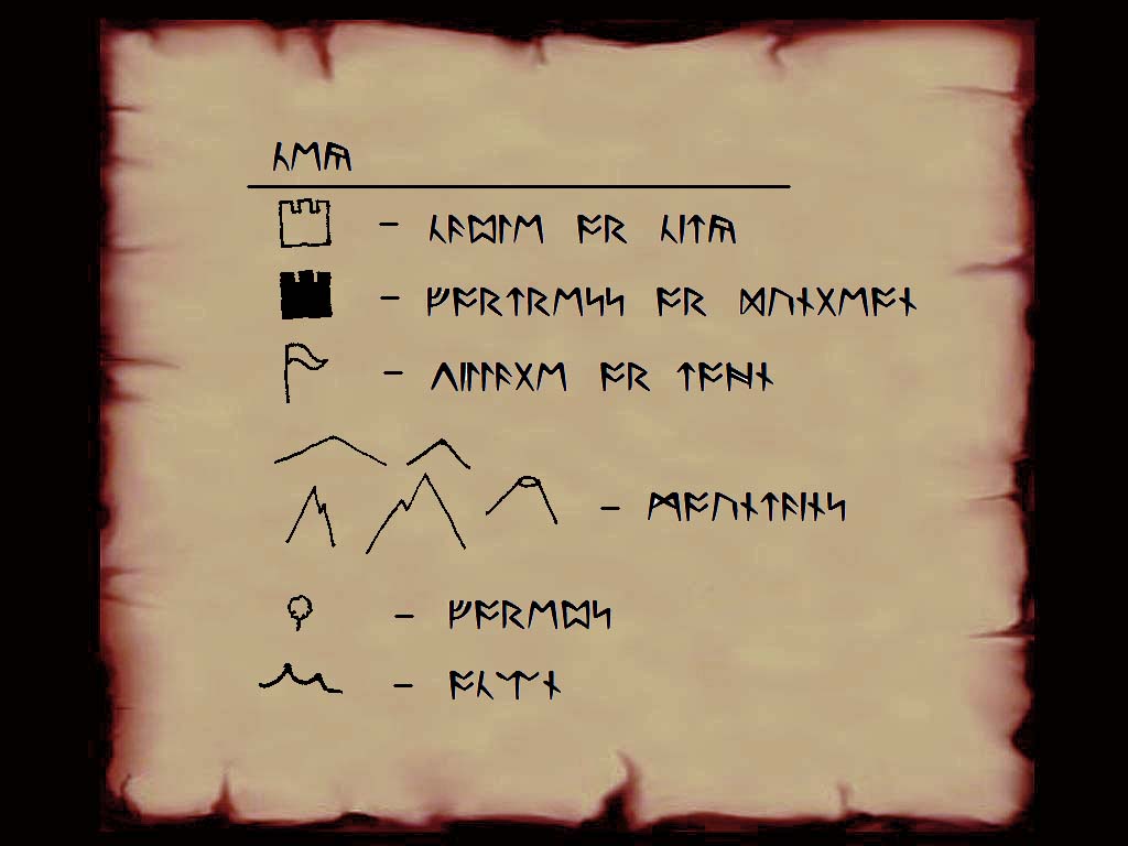
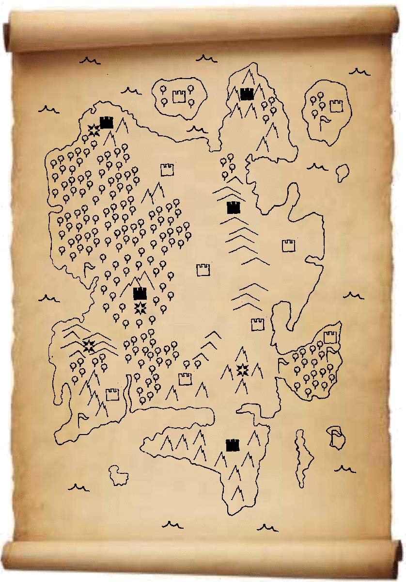
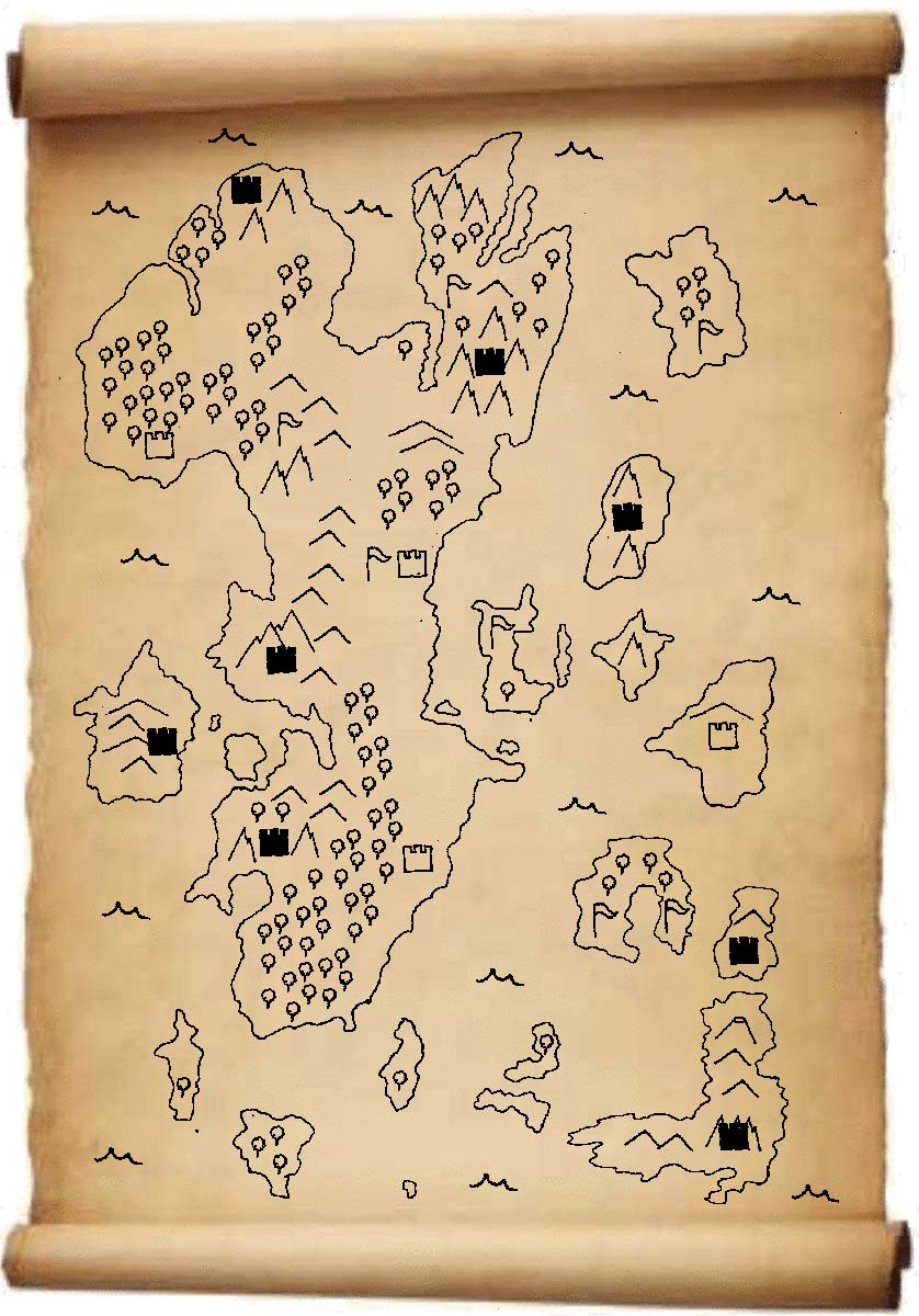
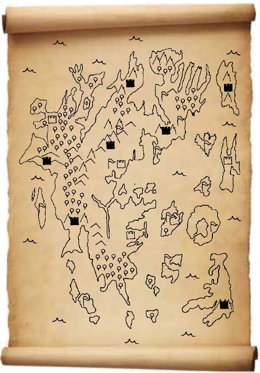
Here are several maps I have copied from other sources that show some of the profound changes to our geography. I have also provided a key which the symbols and notations I could decipher.
Map Key
(http://gl.uorpc.net/images/newspics/Key.jpg)
Map #1 – 700,000 Years Ago
(http://gl.uorpc.net/images/newspics/Map1c.jpg)
Map #2 – The Age of Darkness
(http://gl.uorpc.net/images/newspics/Map2c.jpg)
Map #3 – A Year After the Shattering
(http://gl.uorpc.net/images/newspics/Map3c.jpg)
Map #4 – Five Years After the Shattering
(http://gl.uorpc.net/images/newspics/Map4c.jpg)
Map #5 – Present Day
(http://gl.uorpc.net/images/newspics/Map5c.jpg)
The Followers of Armageddon are planning something major based on the first ancient map. It is your task to decipher the maps and determine the four locations the FoA will hit. E-mail the four locations to malachi@uoem.net. This weekend the Royal Guard will use this information to stop the FoA.
By Gideon of Moonglow
We once believed the stone maps, relics of some ancient people, were wrong. The distances and shapes and positions did not match the world we had measured, and in our arrogance, we did not consider the movement of time. We were the ones who were wrong. The world changes, and even the most sturdy mountain is drifting on a sea of molten lava. We once believed this was all too slow to bother our work. Of course our maps would be good for ten thousand years! Then the Shattering happened, and the world changed again, powerful sorcery tore apart coasts and smashing mountains together.
When a map is drawn, it traps a moment in time. The world moves on from that moment. Cities fall, islands sink, mountains rise. Take nothing for granted.
Here are several maps I have copied from other sources that show some of the profound changes to our geography. I have also provided a key which the symbols and notations I could decipher.
Map Key
(http://gl.uorpc.net/images/newspics/Key.jpg)
Map #1 – 700,000 Years Ago
(http://gl.uorpc.net/images/newspics/Map1c.jpg)
Map #2 – The Age of Darkness
(http://gl.uorpc.net/images/newspics/Map2c.jpg)

Map #3 – A Year After the Shattering
(http://gl.uorpc.net/images/newspics/Map3c.jpg)
Map #4 – Five Years After the Shattering
(http://gl.uorpc.net/images/newspics/Map4c.jpg)

Map #5 – Present Day
(http://gl.uorpc.net/images/newspics/Map5c.jpg)
The Followers of Armageddon are planning something major based on the first ancient map. It is your task to decipher the maps and determine the four locations the FoA will hit. E-mail the four locations to malachi@uoem.net. This weekend the Royal Guard will use this information to stop the FoA.